Epic experiences to have on a Pacific Coast Highway road trip
A road trip along the Pacific Coast Highway, officially known as State Route 1, is the best way to discover California's coast.
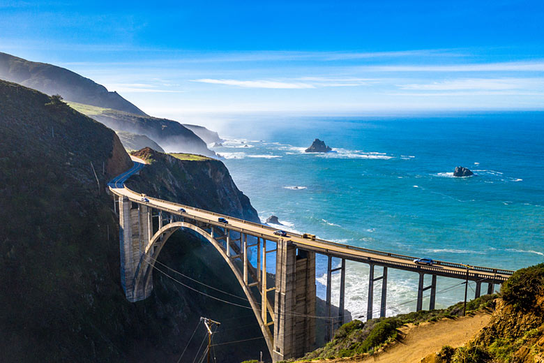
Built in stages, construction began in the 1930s. Today, this legendary road twists and turns dramatically for just over 650 miles from Leggett in Mendocino County, 180 miles north of San Francisco, to San Juan Capistrano in Orange County 55 miles, south of Los Angeles.
It's the stuff California dreams are made of and you'll need to do a little bit of forward planning to get the most out of it, not least allowing for these essential stops along the way.
Getting to California: you can book flights with British Airways* from London to Los Angeles, San Francisco, San Diego and San Jose as well as holidays* including flights, accommodation and/or car hire should you so desire.
Santa Barbara
There are fewer lovelier and more cheerful Californian coastal cities than Santa Barbara, around 90 miles northwest of Los Angeles*. Framed by the Pacific Ocean coast and sun-kissed Santa Ynez Mountains, its setting is magic.
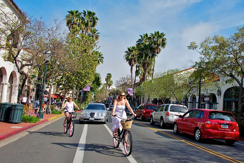
Note its nickname, the American Riviera, for its enchanting combination of Spanish Colonial Revival architecture, fiery Latin heritage, exciting food and wine scene, natural beauty and fine weather.
For an easy introduction, hop on a historic trolley car tour around the town's hotspots to the neighbouring celebrity enclave, Montecito. You can cycle over here, too, on Santa Barbara's stand-alone cycle lane, the Cabrillo Bike Path.
If time lacks for adventures in nearby wine country, many of the region's wineries have tasting rooms in the city; 16 of them make up a tempting trail. You'll find most in The Funk Zone, a buzzy area of vintage shops, restaurants and bars, set in a regenerated industrial area.
Top your day off with an invigorating sunset sail on the Pacific Ocean from one of the various companies found in Santa Barbara Harbor.
Which is the best direction to drive the Pacific Coast Highway? If you drive from north to south, the ocean is directly on your right-hand side and it's easy to stop at viewpoints.
If you drive from south to north, however, the scenery gets increasingly more impressive as you snake your way towards San Francisco and beyond. The decision is yours!
Big Sur
This 90-mile stretch displays California's coastline at its most rugged and dramatic. It's also the oldest and most historic section of the highway. Witnessing its winding turns and seaside cliffs is the main reason most book a Pacific Coast Highway road trip.
Originally called El Sur Grande, or The Big South, referring to the unexplored and unmapped wilderness south of Monterey, it's now the most famous stretch of coast in California.
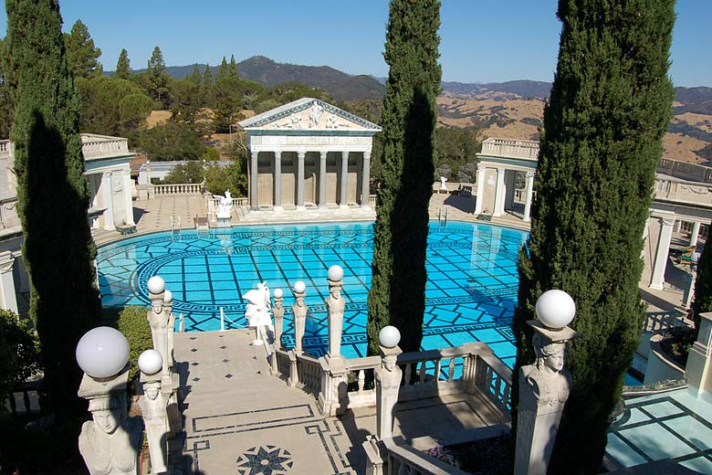
It runs between dainty Carmel on the Monterey Peninsula known for its village feel and fairytale cottages and the smaller beach resort of San Simeon.
You'd stop at the latter to marvel at publishing magnate, William Randolph Hearst's incredible 165-room hilltop estate, Hearst Castle.
From here, you're not far from The Piedras Blancas Rookery for a glimpse of the elephant seals, which number up to 17,000 in peak January, April and October, lolling on the sand.
Big Sur is also the setting for some epic hiking taking you through tree-lined canyons to rocky beaches. Like at The Pfeiffer Falls & Valley, with waterfalls and sweeping views.
Legendary surf spots
With its year-round good, sunny weather, California is a classic surf destination. In fact, surfing was voted the state's official sport in August 2018, and 20 September was named 'California Surfing Day' to commemorate the moment.
Many epic surf spots dot the Pacific Coast Highway. Malibu Lagoon State Beach in Los Angeles, known as Surfrider Beach, is one of the original, and most challenging.
It's also the most famous, thanks to countless appearances in old surf films, like Gidget starring Sally Field. In 2010, it was designated a 'World Surfing Reserve', the first-ever, by a US-based surf spot conservation group, Save the Waves.
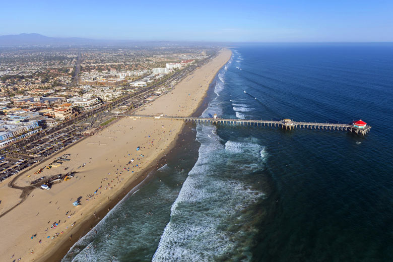
Other iconic surf spots on the route include Huntington Beach in southern Los Angeles. This is where legendary Hawaiian greats surfed as early as the 1920s. Today, it's the setting for the annual Vans US Open of Surfing competition.
When is the best time to drive the Pacific Coast Highway? Although there's something different to experience along this route all year round, early spring, from the middle of March, is undoubtedly the very best time to go. Expect flowers in bloom, plenty of sunshine and quieter roads.
Autumn is another good contender. It is warmer than spring but without the wildflowers. Rain can play havoc with those big sea views in winter, while crowds arrive with the prospect of morning fog in summer.
Solvang, a miniature Danish town
Solvang which means 'sunny field' in Danish, is a homage to the architecture and food of Denmark. Bizarrely it's located slap bang in the Santa Ynez Valley, near Santa Barbara. It is dominated by half-timbered buildings most added in the 1940s when the town was remodelled.
There are Danish bakeries and restaurants to discover, reproductions of Copenhagen's famous Little Mermaid statue and Round Tower, as well as homages to famous Danish author, Hans Christian Andersen.
The town was founded in 1911 by three Danish immigrants keen to preserve their culture and community. They established a Danish 'folk school', where they taught traditional music and literature alongside English language and American history. Today, it's more of a tourist attraction than a real-life Danish community.
Whale watching
Each year between November and May, about 20,000 grey whales make an epic 6,000-mile journey between Alaska and Mexico, and back again.
Sightings are common up and down the Pacific Coast Highway, even in cities: in San Francisco*, at the tip of Point Reyes National Seashore, and in Los Angeles at Point Vicente, nine miles west of San Pedro.
The best spots are at Dana Point in Orange County, a Whale Heritage Site according to the World Cetacean Alliance, for the unusually high number of whales travelling along the stretch of coast and Monterey Bay, two-and-a-half hours south of San Francisco; a historic fish canning area, with many of canneries restored and converted into smart shops and seaside restaurants.
Weather in Calfornia
| Jan | Feb | Mar | Apr | May | Jun | Jul | Aug | Sep | Oct | Nov | Dec | |
|---|---|---|---|---|---|---|---|---|---|---|---|---|
| Maximum daytime temperature °C |  14 14 |
 15 15 |
 14 14 |
 16 16 |
 18 18 |
 21 21 |
 23 23 |
 23 23 |
 23 23 |
 21 21 |
 16 16 |
 13 13 |
| Hours of sunshine (daily) | ||||||||||||
| Days with some rainfall |  9 9 |
 9 9 |
 10 10 |
 6 6 |
 3 3 |
 2 2 |
 1 1 |
 2 2 |
 2 2 |
 4 4 |
 8 8 |
 8 8 |
| Sea temperature °C |  13 13 |
 12 12 |
 12 12 |
 12 12 |
 12 12 |
 12 12 |
 13 13 |
 15 15 |
 15 15 |
 14 14 |
 14 14 |
 13 13 |
The above shows the weather in Big Sur. You can find more about the weather in Los Angeles and the weather in San Francisco in our complete guide to the weather in California.
Ready to road trip? Check out the latest offers on fares with British Airways.
More about California
California by month
Jan Feb Mar Apr May Jun Jul Aug Sep Oct Nov Dec
Explore holiday destinations
- Beach holidays
- City breaks
- Family holidays
- Half term holidays
- Spring holidays
- Summer holidays
- Autumn holidays
- Winter sun holidays
- Honeymoons
- Coolcations
- Compare places
- Ski resorts
Save with latest deals & discounts
- Holiday offers
- Top travel brands
- Airlines & flights
- Discount hotels
- TUI
- Jet2holidays
- Neilson
- Marella Cruises
- Pierre & Vacances
- Caledonian Travel
- Club Med
- January sales
Airport parking
- Manchester Airport
- Stansted Airport
- Bristol Airport
- Luton Airport
- Birmingham Airport
- Edinburgh Airport
- Gatwick Airport
- Glasgow Airport
- Newcastle Airport
Airport lounges
- Manchester Airport
- Birmingham Airport
- Bristol Airport
- Edinburgh Airport
- Glasgow Airport
- Heathrow Airport
- Newcastle Airport
- Stansted Airport
- Gatwick Airport
Be inspired
Get your weekly fix of holiday inspiration from some of the world's best travel writers plus save on your next trip with the latest exclusive offers
We promise not to share your details


