


- Save EXTRA 5% on airport transfers worldwide
- Book private taxis & shuttle buses with discount code
- Enter in coupon box on 'Reservations' page
Arizona weather by month
Check out Arizona weather averages by month. Compare detailed monthly climate statistics including temperature, rainfall and sunshine figures.
| Jan | Feb | Mar | Apr | May | Jun | Jul | Aug | Sep | Oct | Nov | Dec | |
|---|---|---|---|---|---|---|---|---|---|---|---|---|
| Maximum daytime temperature °C |  19 19 |
21 |
 24 24 |
 29 29 |
 34 34 |
39 |
41 |
39 |
37 |
31 |
24 |
19 |
| Hours of sunshine (daily) | ||||||||||||
| Days with some rainfall |  4 4 |
4 |
4 |
 2 2 |
1 |
1 |
4 |
5 |
3 |
3 |
3 |
4 |
More about Arizona
Arizona by month
Jan Feb Mar Apr May Jun Jul Aug Sep Oct Nov Dec
Recommended for Arizona
Show discount code ******WEB
******WEB
Expires at 23:59 on Thursday 31st Dec 2026
The climate guide for Arizona (Phoenix) shows long term monthly weather averages processed from data supplied by CRU (University of East Anglia), the Met Office & the Netherlands Meteorological Institute. Find out more about our data sources.
Arizona climate overview
Located in the southwest, Arizona is one of the largest US states. Famous for its clear, sunny skies and dry weather, and boasting spectacular, diverse scenery, the state is a major tourist magnet. Many Native Americans live in Arizona, and the Navajo Reservation in the north is the nation's largest.
Flat terrain and gently sloping valleys make up the southern and western third of the State, which is home to giant saguaro cacti with their trademark candelabra branches. In summer expect extreme heat and humidity in the south, with low rainfall in the sub-tropical southwest.
Other southern areas experience the 'summer monsoon', when moisture-laden air from the Gulf of Mexico brings thunderstorms in July and August. On occasions these can also penetrate far into the northern highlands. In winter temperatures in the south are mostly comfortable with no significant rain.
From Phoenix the ground rises steadily northwards towards Flagstaff and the highlands of the Colorado Plateau. Desert cacti give way to pine and fir trees as elevation increases. Temperatures in the north are cooler in all months, but rainfall levels still remain low.
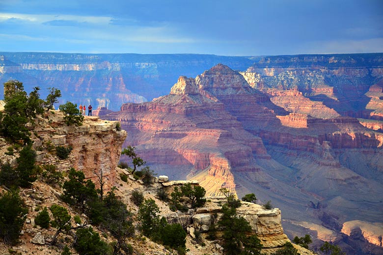
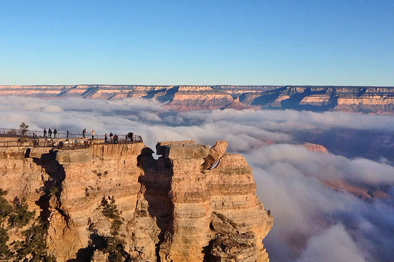
The Grand Canyon slices into the flat, dry semi-desert of the north. Over millions of years, the Colorado and other rivers have carved deep canyons, revealing coloured rocks and soil now thousands of metres deep in places. Despite the increased elevation, the north of Arizona is still warm to hot in summer. However, winters are cold to below freezing with snows on the central peaks around Flagstaff.
Top Arizona destinations
Below are average maximum temperatures at popular countries, regions and places in Arizona for next month - September. Select a destination to see the climate guide for all months of the year.

All Arizona destinations
Arizona weather averages
Temperature in Arizona (°C)
| Jan | Feb | Mar | Apr | May | Jun | Jul | Aug | Sep | Oct | Nov | Dec | |
|---|---|---|---|---|---|---|---|---|---|---|---|---|
| Max temperature (daytime) | 19 |
21 |
24 |
29 |
34 |
39 |
41 |
39 |
37 |
31 |
24 |
19 |
| Min temperature (night-time) |  4 4 |
6 |
 8 8 |
11 |
 16 16 |
20 |
25 |
24 |
21 |
 14 14 |
8 |
4 |
| Heat & Humidity |  0 0 |
0 |
0 |
 L L |
 H H |
 VH VH |
 E E |
VH |
VH |
 M M |
0 |
0 |
Note: 0 = None, L = Low, M = Moderate, H = High, VH = Very high, E = Extreme
Sunshine & UV index in Arizona
| Jan | Feb | Mar | Apr | May | Jun | Jul | Aug | Sep | Oct | Nov | Dec | |
|---|---|---|---|---|---|---|---|---|---|---|---|---|
| Daily hours of sunshine | ||||||||||||
| Daily hours of daylight |  10 10 |
 11 11 |
 12 12 |
 13 13 |
 14 14 |
14 |
14 |
13 |
12 |
11 |
10 |
10 |
| UV Index (Maximum) |  3 3 |
4 |
 6 6 |
 8 8 |
10 |
10 |
 11 11 |
10 |
8 |
6 |
4 |
3 |
Rainfall in Arizona
| Jan | Feb | Mar | Apr | May | Jun | Jul | Aug | Sep | Oct | Nov | Dec | |
|---|---|---|---|---|---|---|---|---|---|---|---|---|
| Number of days with some rain | 4 |
4 |
4 |
2 |
1 |
1 |
4 |
5 |
3 |
3 |
3 |
4 |
| Average monthly rainfall (mm) |  24 24 |
21 |
26 |
 7 7 |
4 |
3 |
22 |
32 |
23 |
17 |
20 |
25 |
Compare Arizona weather with the UK
The weather chart below compares the average monthly maximum daytime temperature for Arizona, USA (Phoenix) and the UK (London).
Maximum daytime temperature (°C)
Arizona, USA (Phoenix)
UK (London)
Jan
Feb
Mar
Apr
May
Jun
Jul
Aug
Sep
Oct
Nov
Dec
Metric (°C / mm) | Imperial (°F / inches)
More about Arizona

Be inspired
Get your weekly fix of holiday inspiration from some of the world's best travel writers plus save on your next trip with the latest exclusive offers
We promise not to share your details
Related posts


Popular travel offers


Explore holiday destinations
- Beach holidays
- City breaks
- Family holidays
- Half term holidays
- Spring holidays
- Summer holidays
- Autumn holidays
- Winter sun holidays
- Honeymoons
- Coolcations
- Compare places
- Ski resorts
Save with latest deals & discounts
- Holiday offers
- Top travel brands
- Airlines & flights
- Discount hotels
- TUI
- Jet2holidays
- Neilson
- Marella Cruises
- Holiday Extras
- Pierre & Vacances
- Caledonian Travel
- Club Med
Airport parking
- Manchester Airport
- Stansted Airport
- Bristol Airport
- Luton Airport
- Birmingham Airport
- Edinburgh Airport
- Gatwick Airport
- Glasgow Airport
- Newcastle Airport
Airport lounges
- Manchester Airport
- Birmingham Airport
- Bristol Airport
- Edinburgh Airport
- Glasgow Airport
- Heathrow Airport
- Newcastle Airport
- Stansted Airport
- Gatwick Airport